
Dear Florida Nature Coast Horticulture Industry and other Central Florida Ag Industries,
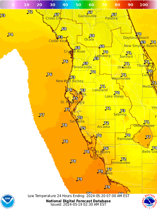
The National Weather Service (NWS, http://www.weather.gov/) has issued a Hard Freeze Warning for most of Peninsular Florida from 9 pm Monday (January 6, 2014) to 11 am Tuesday (January 7, 2014). A hard freeze warning means that temperatures are predicted to be below 27 degrees F for more than 2 hours in a 12 hour time frame. For your convenience, the NWS hard freeze warning and NWS image of predicted temperatures have been included at the bottom of this post.
You can monitor real time weather using the Florida Automated Weather Network (FAWN) at http://fawn.ifas.ufl.edu/. FAWN has a cold protection tab which in includes the following items: cold protection tool kit (minimum overnight temperature - calculated), Evaporative Cooling Potential, Wet Bulb Based Irrigation Cut off, and Citrus Leaf Freezing Temperature.
Please take appropriate actions in the next 24 hours to protect plant materials, crops, and animals.
Feel free to contact me, if you have any questions.
Stay Warm!
Sincerely,
Cami Esmel McAvoy
Hard Freeze Warning
URGENT - WEATHER MESSAGE
NATIONAL WEATHER SERVICE JACKSONVILLE FL
608 PM EST SUN JAN 5 2014

FLZ020>023-030>032-035>037-GAZ132>136-149>153-162>165-060715-
/O.CON.KJAX.HZ.W.0001.140107T0200Z-140107T1600Z/
HAMILTON-SUWANNEE-COLUMBIA-BAKER-UNION-BRADFORD-CLAY-GILCHRIST-
ALACHUA-PUTNAM-COFFEE-JEFF DAVIS-BACON-APPLING-WAYNE-ATKINSON-
WARE-PIERCE-BRANTLEY-INLAND GLYNN-ECHOLS-CLINCH-CHARLTON-
INLAND CAMDEN-
INCLUDING THE CITIES OF...JASPER...LIVE OAK...LAKE CITY...
MACCLENNY...LAKE BUTLER...STARKE...GREEN COVE SPRINGS...TRENTON...
GAINESVILLE...PALATKA...DOUGLAS...HAZLEHURST...ALMA...BAXLEY...
JESUP...PEARSON...WAYCROSS...BLACKSHEAR...NAHUNTA...STATENVILLE...
HOMERVILLE...FOLKSTON...WOODBINE
608 PM EST SUN JAN 5 2014

...HARD FREEZE WARNING REMAINS IN EFFECT FROM 9 PM MONDAY TO
11 AM EST TUESDAY...

* TEMPERATURE...LOWS 15 TO 20 INLAND...20 TO 25 CLOSER TO THE
  COAST. 10 TO 14 HOURS OF HARD FREEZE CONDITIONS EXPECTED.

* IMPACTS...AN EXTENDED PERIOD OF HARD FREEZE CONDITIONS CAN
  CAUSE EXPOSED WATER PIPES TO BURST. A THREAT TO SENSITIVE
  VEGETATION AND LIVESTOCK EXISTS. THESE CONDITIONS ARE ALSO
  POTENTIALLY HAZARDOUS TO PEOPLE AND PETS WHO ARE VULNERABLE TO
  THE COLD.

PRECAUTIONARY/PREPAREDNESS ACTIONS...

A HARD FREEZE WARNING MEANS THAT TEMPERATURES LESS THAN
27 DEGREES ARE EXPECTED FOR AT LEAST 2 HOURS.

&&

$$
No comments:
Post a Comment